Fractures in Carbonate-Bearing Rocks at Mars' Huygens Basin

Some of Mars' Missing Carbon Dioxide May be Buried
Rocks on Mars dug from far underground by crater-blasting impacts are providing glimpses of one possible way Mars' atmosphere has become much less dense than it used to be.
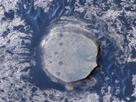
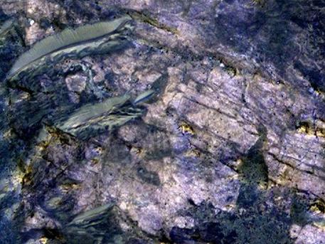
This image from orbit covers an area about 460 meters (about 1,500 feet) across, in which carbonate minerals have been identified from spectrometer observations. Fractures and possible layers are visible in the light-toned rock exposure containing the carbonates.

The location is inside an unnamed crater about 35 kilometers (22 miles) in diameter that is on the uplifted rim of Huygens crater, which is 467 kilometers (290 miles) in diameter. The excavations by the impacts that dug first Huygens and then the smaller crater have exposed material in this image that had been buried an estimated 5 kilometers (3 miles) deep. The carbonates may be from part of an extensive buried layer that could hold much of the carbon that was once in a thick Martian atmosphere of carbon dioxide, some researchers propose. Mars now has a thin atmosphere that is mostly carbon dioxide, but evidence that liquid water was once widespread on the surface suggests the atmosphere was much thicker billions of years ago.

The High Resolution Imaging Science Experiment (HiRISE) camera on NASA's Mars Reconnaissance Orbiter provided this image. Identification of iron or calcium carbonates at this site, and also of clay minerals indicating a formerly wet environment, comes from an observation by the Compact Reconnaissance Imaging Spectrometer for Mars (CRISM) on the same orbiter. In the presence of water and other conditions, carbon dioxide in the atmosphere can be captured into carbonate minerals.

The image is presented in false color, making differences in surface composition more visible than they would appear to the human eye. It combines information collected separately in red, blue-green, and near-infrared wavelengths.

The image is from HiRISE observation ESP_012897_168, made on April 27, 2009, and centered at 11.6 degrees south latitude, 51.9 degrees east longitude. Other image products from this observation are available at http://hirise.lpl.arizona.edu/ESP_012897_1685 .

HiRISE is operated by the University of Arizona, Tucson. The instrument was built by Ball Aerospace & Technologies Corp., Boulder, Colo. The Johns Hopkins University Applied Physics Laboratory, Laurel, Md., led the effort to build the CRISM instrument and operates CRISM in coordination with an international team of researchers from universities, government and the private sector. NASA's Jet Propulsion Laboratory, a division of the California Institute of Technology in Pasadena, manages the Mars Reconnaissance Orbiter for NASA's Science Mission Directorate, Washington. Lockheed Martin Space Systems, Denver, is NASA's industry partner for the mission and built the spacecraft.

This image from orbit covers an area about 460 meters (about 1,500 feet) across, in which carbonate minerals have been identified from spectrometer observations. Fractures and possible layers are visible in the light-toned rock exposure containing the carbonates. The location is inside an unnamed crater about 35 kilometers (22 miles) in diameter that is on the uplifted rim of Huygens crater, which is 467 kilometers (290 miles) in diameter. The excavations by the impacts that dug first Huygens and then the smaller crater have exposed material in this image that had been buried an estimated 5 kilometers (3 miles) deep. The carbonates may be from part of an extensive buried layer that could hold much of the carbon that was once in a thick Martian atmosphere of carbon dioxide, some researchers propose. Mars now has a thin atmosphere that is mostly carbon dioxide, but evidence that liquid water was once widespread on the surface suggests the atmosphere was much thicker billions of years ago. The High Resolution Imaging Science Experiment (HiRISE) camera on NASA's Mars Reconnaissance Orbiter provided this image. Identification of iron or calcium carbonates at this site, and also of clay minerals indicating a formerly wet environment, comes from an observation by the Compact Reconnaissance Imaging Spectrometer for Mars (CRISM) on the same orbiter. In the presence of water and other conditions, carbon dioxide in the atmosphere can be captured into carbonate minerals. The image is presented in false color, making differences in surface composition more visible than they would appear to the human eye. It combines information collected separately in red, blue-green, and near-infrared wavelengths. The image is from HiRISE observation ESP_012897_168, made on April 27, 2009, and centered at 11.6 degrees south latitude, 51.9 degrees east longitude. Other image products from this observation are available at http://hirise.lpl.arizona.edu/ESP_012897_1685 . HiRISE is operated by the University of Arizona, Tucson. The instrument was built by Ball Aerospace & Technologies Corp., Boulder, Colo. The Johns Hopkins University Applied Physics Laboratory, Laurel, Md., led the effort to build the CRISM instrument and operates CRISM in coordination with an international team of researchers from universities, government and the private sector. NASA's Jet Propulsion Laboratory, a division of the California Institute of Technology in Pasadena, manages the Mars Reconnaissance Orbiter for NASA's Science Mission Directorate, Washington. Lockheed Martin Space Systems, Denver, is NASA's industry partner for the mission and built the spacecraft.

At several places where cratering has exposed material from depths of about 5 kilometers (3 miles) or more beneath the surface, observations by a mineral-mapping instrument on NASA's Mars Reconnaissance Orbiter indicate carbonate minerals.

These are not the first detections of carbonates on Mars. However, compared to earlier findings, they bear closer resemblance to what some scientists have theorized for decades about the whereabouts of Mars' "missing" carbon. If deeply buried carbonate layers are found to be widespread, they would help answer questions about the disappearance of most of ancient Mars' atmosphere, which is deduced to have been thick and mostly carbon dioxide. The carbon that goes into formation of carbonate minerals can come from atmospheric carbon dioxide.

"We're looking at a pretty lucky location in terms of exposing something that was deep beneath the surface," said planetary scientist James Wray of Cornell University, Ithaca, N.Y., who reported the latest carbonate findings today at the Lunar and Planetary Science Conference near Houston. Huygens crater, a basin 467 kilometers (290 miles) in diameter in the southern highlands of Mars, had already hoisted material from far underground, and then the rim of Huygens, containing the lifted material, was drilled into by a smaller, unnamed cratering event.

Observations in the high-resolution mode of the Compact Reconnaissance Imaging Spectrometer for Mars (CRISM) instrument on the Mars Reconnaissance Orbiter show spectral characteristics of calcium or iron carbonate at this site. Detections of clay minerals in lower-resolution mapping mode by CRISM had prompted closer examination with the spectrometer, and the carbonates are found near the clay minerals. Both types of minerals typically form in wet environments.

The occurrence of this type of carbonate in association with the largest impact features suggests that it was buried by a few kilometers (or miles) of younger rocks, possibly including volcanic flows and fragmented material ejected from other, nearby impacts.

These findings reinforce a report by other researchers five months ago identifying the same types of carbonate and clay minerals from CRISM observation of a site about 1,000 kilometers (600 miles) away. At that site, a meteor impact has exposed rocks from deep underground, inside Leighton crater. In their report of that discovery, Joseph Michalski of the Planetary Science Institute, Tucson, Ariz., and Paul Niles of NASA Johnson Space Center, Houston, proposed that the carbonates at Leighton "might be only a small part of a much more extensive ancient sedimentary record that has been buried by volcanic resurfacing and impact ejecta."

Carbonates found in rocks elsewhere on Mars, from orbit and by NASA's Spirit rover, are rich in magnesium. Those could form from reaction of volcanic deposits with moisture, Wray said. "The broader compositional range we're seeing that includes iron-rich and calcium-rich carbonates couldn't form as easily from just a little bit of water reacting with igneous rocks. Calcium carbonate is what you typically find on Earth's ocean and lake floors."

He said the carbonates at Huygens and Leighton "fit what would be expected from atmospheric carbon dioxide interacting with ancient bodies of water on Mars." Key additional evidence would be to find similar deposits in other regions of Mars. A hunting guide for that search is the CRISM low-resolution mapping, which has covered about three-fourths of the planet and revealed clay-mineral deposits at thousands of locations.

"A dramatic change in atmospheric density remains one of the most intriguing possibilities about early Mars," said Mars Reconnaissance Orbiter Project Scientist Richard Zurek, of NASA's Jet Propulsion Laboratory, Pasadena, Calif. "Increasing evidence for liquid water on the surface of ancient Mars for extended periods continues to suggest that the atmosphere used to be much thicker."

Carbon dioxide makes up nearly all of today's Martian air and likely was most of a thicker early atmosphere, too. In today's thin, cold atmosphere, liquid water quickly freezes or boils away.

What became of that carbon dioxide? NASA will launch the Mars Atmosphere and Volatile Evolution Mission (MAVEN) in 2013 to investigate processes that could have stripped the gas from the top of the atmosphere into interplanetary space. Meanwhile, CRISM and other instruments now in orbit continue to look for evidence that some of the carbon dioxide in that ancient atmosphere was removed, in the presence of liquid water, by formation of carbonate minerals now buried far beneath the present surface.

Source: NASA
Fractures in Carbonate-Bearing Rocks at Mars' Huygens Basin - Some of Mars' Missing Carbon Dioxide May be Buried | Redshift live

Fractures in Carbonate-Bearing Rocks at Mars' Huygens Basin

Some of Mars' Missing Carbon Dioxide May be Buried

Rocks on Mars dug from far underground by crater-blasting impacts are providing glimpses of one possible way Mars' atmosphere has become much less dense than it used to be.
This image from orbit covers an area about 460 meters (about 1,500 feet) across, in which carbonate minerals have been identified from spectrometer observations. Fractures and possible layers are visible in the light-toned rock exposure containing the carbonates.

The location is inside an unnamed crater about 35 kilometers (22 miles) in diameter that is on the uplifted rim of Huygens crater, which is 467 kilometers (290 miles) in diameter. The excavations by the impacts that dug first Huygens and then the smaller crater have exposed material in this image that had been buried an estimated 5 kilometers (3 miles) deep. The carbonates may be from part of an extensive buried layer that could hold much of the carbon that was once in a thick Martian atmosphere of carbon dioxide, some researchers propose. Mars now has a thin atmosphere that is mostly carbon dioxide, but evidence that liquid water was once widespread on the surface suggests the atmosphere was much thicker billions of years ago.

The High Resolution Imaging Science Experiment (HiRISE) camera on NASA's Mars Reconnaissance Orbiter provided this image. Identification of iron or calcium carbonates at this site, and also of clay minerals indicating a formerly wet environment, comes from an observation by the Compact Reconnaissance Imaging Spectrometer for Mars (CRISM) on the same orbiter. In the presence of water and other conditions, carbon dioxide in the atmosphere can be captured into carbonate minerals.

The image is presented in false color, making differences in surface composition more visible than they would appear to the human eye. It combines information collected separately in red, blue-green, and near-infrared wavelengths.

The image is from HiRISE observation ESP_012897_168, made on April 27, 2009, and centered at 11.6 degrees south latitude, 51.9 degrees east longitude. Other image products from this observation are available at http://hirise.lpl.arizona.edu/ESP_012897_1685 .

HiRISE is operated by the University of Arizona, Tucson. The instrument was built by Ball Aerospace & Technologies Corp., Boulder, Colo. The Johns Hopkins University Applied Physics Laboratory, Laurel, Md., led the effort to build the CRISM instrument and operates CRISM in coordination with an international team of researchers from universities, government and the private sector. NASA's Jet Propulsion Laboratory, a division of the California Institute of Technology in Pasadena, manages the Mars Reconnaissance Orbiter for NASA's Science Mission Directorate, Washington. Lockheed Martin Space Systems, Denver, is NASA's industry partner for the mission and built the spacecraft.

This image from orbit covers an area about 460 meters (about 1,500 feet) across, in which carbonate minerals have been identified from spectrometer observations. Fractures and possible layers are visible in the light-toned rock exposure containing the carbonates. The location is inside an unnamed crater about 35 kilometers (22 miles) in diameter that is on the uplifted rim of Huygens crater, which is 467 kilometers (290 miles) in diameter. The excavations by the impacts that dug first Huygens and then the smaller crater have exposed material in this image that had been buried an estimated 5 kilometers (3 miles) deep. The carbonates may be from part of an extensive buried layer that could hold much of the carbon that was once in a thick Martian atmosphere of carbon dioxide, some researchers propose. Mars now has a thin atmosphere that is mostly carbon dioxide, but evidence that liquid water was once widespread on the surface suggests the atmosphere was much thicker billions of years ago. The High Resolution Imaging Science Experiment (HiRISE) camera on NASA's Mars Reconnaissance Orbiter provided this image. Identification of iron or calcium carbonates at this site, and also of clay minerals indicating a formerly wet environment, comes from an observation by the Compact Reconnaissance Imaging Spectrometer for Mars (CRISM) on the same orbiter. In the presence of water and other conditions, carbon dioxide in the atmosphere can be captured into carbonate minerals. The image is presented in false color, making differences in surface composition more visible than they would appear to the human eye. It combines information collected separately in red, blue-green, and near-infrared wavelengths. The image is from HiRISE observation ESP_012897_168, made on April 27, 2009, and centered at 11.6 degrees south latitude, 51.9 degrees east longitude. Other image products from this observation are available at http://hirise.lpl.arizona.edu/ESP_012897_1685 . HiRISE is operated by the University of Arizona, Tucson. The instrument was built by Ball Aerospace & Technologies Corp., Boulder, Colo. The Johns Hopkins University Applied Physics Laboratory, Laurel, Md., led the effort to build the CRISM instrument and operates CRISM in coordination with an international team of researchers from universities, government and the private sector. NASA's Jet Propulsion Laboratory, a division of the California Institute of Technology in Pasadena, manages the Mars Reconnaissance Orbiter for NASA's Science Mission Directorate, Washington. Lockheed Martin Space Systems, Denver, is NASA's industry partner for the mission and built the spacecraft.

At several places where cratering has exposed material from depths of about 5 kilometers (3 miles) or more beneath the surface, observations by a mineral-mapping instrument on NASA's Mars Reconnaissance Orbiter indicate carbonate minerals.

These are not the first detections of carbonates on Mars. However, compared to earlier findings, they bear closer resemblance to what some scientists have theorized for decades about the whereabouts of Mars' "missing" carbon. If deeply buried carbonate layers are found to be widespread, they would help answer questions about the disappearance of most of ancient Mars' atmosphere, which is deduced to have been thick and mostly carbon dioxide. The carbon that goes into formation of carbonate minerals can come from atmospheric carbon dioxide.

"We're looking at a pretty lucky location in terms of exposing something that was deep beneath the surface," said planetary scientist James Wray of Cornell University, Ithaca, N.Y., who reported the latest carbonate findings today at the Lunar and Planetary Science Conference near Houston. Huygens crater, a basin 467 kilometers (290 miles) in diameter in the southern highlands of Mars, had already hoisted material from far underground, and then the rim of Huygens, containing the lifted material, was drilled into by a smaller, unnamed cratering event.

Observations in the high-resolution mode of the Compact Reconnaissance Imaging Spectrometer for Mars (CRISM) instrument on the Mars Reconnaissance Orbiter show spectral characteristics of calcium or iron carbonate at this site. Detections of clay minerals in lower-resolution mapping mode by CRISM had prompted closer examination with the spectrometer, and the carbonates are found near the clay minerals. Both types of minerals typically form in wet environments.

The occurrence of this type of carbonate in association with the largest impact features suggests that it was buried by a few kilometers (or miles) of younger rocks, possibly including volcanic flows and fragmented material ejected from other, nearby impacts.

These findings reinforce a report by other researchers five months ago identifying the same types of carbonate and clay minerals from CRISM observation of a site about 1,000 kilometers (600 miles) away. At that site, a meteor impact has exposed rocks from deep underground, inside Leighton crater. In their report of that discovery, Joseph Michalski of the Planetary Science Institute, Tucson, Ariz., and Paul Niles of NASA Johnson Space Center, Houston, proposed that the carbonates at Leighton "might be only a small part of a much more extensive ancient sedimentary record that has been buried by volcanic resurfacing and impact ejecta."

Carbonates found in rocks elsewhere on Mars, from orbit and by NASA's Spirit rover, are rich in magnesium. Those could form from reaction of volcanic deposits with moisture, Wray said. "The broader compositional range we're seeing that includes iron-rich and calcium-rich carbonates couldn't form as easily from just a little bit of water reacting with igneous rocks. Calcium carbonate is what you typically find on Earth's ocean and lake floors."

He said the carbonates at Huygens and Leighton "fit what would be expected from atmospheric carbon dioxide interacting with ancient bodies of water on Mars." Key additional evidence would be to find similar deposits in other regions of Mars. A hunting guide for that search is the CRISM low-resolution mapping, which has covered about three-fourths of the planet and revealed clay-mineral deposits at thousands of locations.

"A dramatic change in atmospheric density remains one of the most intriguing possibilities about early Mars," said Mars Reconnaissance Orbiter Project Scientist Richard Zurek, of NASA's Jet Propulsion Laboratory, Pasadena, Calif. "Increasing evidence for liquid water on the surface of ancient Mars for extended periods continues to suggest that the atmosphere used to be much thicker."

Carbon dioxide makes up nearly all of today's Martian air and likely was most of a thicker early atmosphere, too. In today's thin, cold atmosphere, liquid water quickly freezes or boils away.

What became of that carbon dioxide? NASA will launch the Mars Atmosphere and Volatile Evolution Mission (MAVEN) in 2013 to investigate processes that could have stripped the gas from the top of the atmosphere into interplanetary space. Meanwhile, CRISM and other instruments now in orbit continue to look for evidence that some of the carbon dioxide in that ancient atmosphere was removed, in the presence of liquid water, by formation of carbonate minerals now buried far beneath the present surface.

Source: NASA
» print article
Related articles:
This image, combining data from two instruments aboard NASA's Mars Global Surveyor, depicts an orbital view of the north polar region of Mars.
PASADENA, Calif.

Orbiter Penetrates Mysteries of Martian Ice Cap

» go to article
This view of an inverted crater in the Arabia Terra region of Mars is among the images taken by NASA's Mars Reconnaissance Orbiter in early 2010 as the spacecraft approached the 100-terabit milestone in total data returned.
Passing The Download Limit

Mars Orbiter Speeds Past Data Milestone

» go to article
In a region of the south pole known informally as "Ithaca" numerous fans of dark frost form every spring. Fans are dark, but small narrow bright streaks can be detected.
Mars Orbiter

Mars Orbiter Examines 'Lace' and 'Lizard Skin' Terrain

» go to article
Image shows Grad student Nicholas Boyd (left) and Principal Investigator Ralf Gellert, both of the University of Guelph, Ontario, Canada, preparing for the installation of the sensor head on the Alpha Particle X-ray Spectrometer instrument during testing at NASA's Jet Propulsion Laboratory.The instrument is part of the Curiosity rover, which will fly on NASA's Mars Science Laboratory mission. The sensor head is 7.8 centimeters, or about 3 inches tall.
Alpha Particle X-ray

Advanced NASA Instrument Gets Close-up on Mars Rocks

» go to article
NASA's Goddard Space Flight Center, Greenbelt, Md., built SAM. The 40-kilogram (88-pound) instrument includes three laboratory tools for analyzing chemistry, plus mechanisms for handling and processing samples.

In this photograph, technicians and engineers inside a clean room at NASA's Jet Propulsion Laboratory, Pasadena, Calif., prepare to install SAM into the mission's Mars rover, Curiosity. The photograph was taken on Jan. 6, 2011.

The analytical tools in SAM are a mass spectrometer built by NASA Goddard, a gas chromatograph built by French partners supported by France's national space agency in Paris, and a laser spectrometer built by JPL. SAM's sample manipulation system, including 74 sample cups for carrying powdered samples to two ovens, was built by Honeybee Robotics, New York. Curiosity's robotic arm will deliver powdered samples, drilled from rocks or scooped from soil, to SAM's inlet tubes on top of the rover deck. Ovens will heat most samples to about 1,000 degrees Celsius (about 1,800 degrees Fahrenheit). SAM will take in atmospheric samples through separate ports on the side of the rover. Inside SAM are more than 600 meters (more than 650 yards) of wiring, 52 microvalves, a saft-drink-can-size pump that rotates 100,000 times per minute, and many other components.

NASA will launch Curiosity from Florida between Nov. 25 and Dec. 18, 2011, together with other parts of the Mars Science Laboratory spacecraft for delivering the rover to the surface of Mars in August, 2012. During a prime mission lasting one Mars year (two Earth years), researchers will use the rover in one of the most intriguing areas of Mars to investigate whether conditions there have been favorable for microbial life and favorable for preserving evidence about whether life has existed.
Lifting SAM Instrument for Installation into Mars Rover

NASA Mars Rover Will Check for Ingredients of Life

» go to article
The Mars Climate Sounder instrument on NASA's Mars Reconnaissance Orbiter maps the vertical distribution of temperatures, dust, water vapor and ice clouds in the Martian atmosphere as the orbiter flies a near-polar orbit.

This example of data from the instrument shows 13 orbits of nighttime temperatures at altitudes of zero to 80 kilometers (50 miles) above the surface, presented as curtains along the orbital track. Temperatures range from 120 Kelvin (minus 244 degrees Fahrenheit), coded purple, to 200 Kelvin (minus 100 degrees Fahrenheit), coded green.

The data are from March 1, 2008, which was during early spring on northern Mars. The globe of Mars depicted under the curtains is a Google Earth product using elevation data from the Mars Orbiter Laser Altimeter on NASA's Mars Global Surveyor.

The ExoMars Climate Sounder, selected in August 2010 as part of the science payload for the 2016 ExoMars Trace Gas Orbiter mission, will resemble the Mars Climate Sounder and provide similar types of data sets. The 2016 mission is a collaboration of the European Space Agency and NASA.
ExoMars

Tracing the Big Picture of Mars' Atmosphere

» go to article
Valles Marineris, the "Grand Canyon of Mars," sprawls wide enough to reach from Los Angeles to nearly New York City, if it were located on Earth. The red outline box shows the location of a second, full-resolution image.
Red Planet

NASA Spacecraft Camera Yields Most Accurate Mars Map

» go to article
Lyot Crater, pictured here, is one of at least nine craters in the northern lowlands of Mars with exposures of hydrated minerals detected from orbit, according to a June 25, 2010, report.

These minerals, including phyllosilicates, have previously been found in thousands of small outcrops in the southern highlands of Mars, but had not previously been identified in the northern lowlands, which cover nearly half of the planet. The plentiful outcrops in the south have been interpreted as evidence that early Mars -- about 4 billion years ago -- had wet conditions necessary for producing phyllosilicates and possibly conducive to life.
PASADENA, Calif.

New Clues Suggest Wet Era on Early Mars Was Global

» go to article
The small round black spot in this THEMIS image may be a hole in the roof of a Martian lava tube or cave.
Students find Mars-Crater

Middle-school project discovers cave skylight on Mars

» go to article
This oblique view shows geological layers of rock exposed on a mound inside Gale Crater on Mars. This is a lower portion of the mound, with the crater floor at the left (and lowest) edge of the image. Layers near the bottom of the mound contain clay and sulfate minerals that indicate wet conditions. Overlying rock layers contain sulfates with little or no clay, consistent with these layers forming in an environment in which water was evaporating and Mars was drying out.
Layered Crater

Mars Crater Records a History of Changes

» go to article
NASA's Mars Exploration Rover Opportunity examined a rock called "Marquette Island." Studies of texture and composition suggest that this rock, not much bigger than a basketball, originated deep inside the Martian crust. A crater-digging impact could have excavated the rock and thrown it a long distance, to where Opportunity found it along the rover's long trek across the Meridiani plain toward Endeavour Crater.
On the Road Again

"Opportunity" to View Interior of Mars

» go to article
Dunes of sand-sized materials have been trapped on the floors of many Martian craters. This is one example, from a crater in Noachis Terra, west of the giant Hellas impact basin.
Mars Orbiter Resumes Duty

New Stunning Pictures from Mars

» go to article
Search
Astronomy Software

Solar Eclipse by Redshift

Solar Eclipse by Redshift for iOS

Observe, understand, and marvel at the solar eclipse on August 21, 2017! » more

Solar Eclipse by Redshift

Solar Eclipse by Redshift for Android

Observe, understand, and marvel at the solar eclipse on August 21, 2017! » more

Fractures in Carbonate-Bearing Rocks at Mars' Huygens Basin

Some of Mars' Missing Carbon Dioxide May be Buried

Rocks on Mars dug from far underground by crater-blasting impacts are providing glimpses of one possible way Mars' atmosphere has become much less dense than it used to be.
This image from orbit covers an area about 460 meters (about 1,500 feet) across, in which carbonate minerals have been identified from spectrometer observations. Fractures and possible layers are visible in the light-toned rock exposure containing the carbonates.

The location is inside an unnamed crater about 35 kilometers (22 miles) in diameter that is on the uplifted rim of Huygens crater, which is 467 kilometers (290 miles) in diameter. The excavations by the impacts that dug first Huygens and then the smaller crater have exposed material in this image that had been buried an estimated 5 kilometers (3 miles) deep. The carbonates may be from part of an extensive buried layer that could hold much of the carbon that was once in a thick Martian atmosphere of carbon dioxide, some researchers propose. Mars now has a thin atmosphere that is mostly carbon dioxide, but evidence that liquid water was once widespread on the surface suggests the atmosphere was much thicker billions of years ago.

The High Resolution Imaging Science Experiment (HiRISE) camera on NASA's Mars Reconnaissance Orbiter provided this image. Identification of iron or calcium carbonates at this site, and also of clay minerals indicating a formerly wet environment, comes from an observation by the Compact Reconnaissance Imaging Spectrometer for Mars (CRISM) on the same orbiter. In the presence of water and other conditions, carbon dioxide in the atmosphere can be captured into carbonate minerals.

The image is presented in false color, making differences in surface composition more visible than they would appear to the human eye. It combines information collected separately in red, blue-green, and near-infrared wavelengths.

The image is from HiRISE observation ESP_012897_168, made on April 27, 2009, and centered at 11.6 degrees south latitude, 51.9 degrees east longitude. Other image products from this observation are available at http://hirise.lpl.arizona.edu/ESP_012897_1685 .

HiRISE is operated by the University of Arizona, Tucson. The instrument was built by Ball Aerospace & Technologies Corp., Boulder, Colo. The Johns Hopkins University Applied Physics Laboratory, Laurel, Md., led the effort to build the CRISM instrument and operates CRISM in coordination with an international team of researchers from universities, government and the private sector. NASA's Jet Propulsion Laboratory, a division of the California Institute of Technology in Pasadena, manages the Mars Reconnaissance Orbiter for NASA's Science Mission Directorate, Washington. Lockheed Martin Space Systems, Denver, is NASA's industry partner for the mission and built the spacecraft.

This image from orbit covers an area about 460 meters (about 1,500 feet) across, in which carbonate minerals have been identified from spectrometer observations. Fractures and possible layers are visible in the light-toned rock exposure containing the carbonates. The location is inside an unnamed crater about 35 kilometers (22 miles) in diameter that is on the uplifted rim of Huygens crater, which is 467 kilometers (290 miles) in diameter. The excavations by the impacts that dug first Huygens and then the smaller crater have exposed material in this image that had been buried an estimated 5 kilometers (3 miles) deep. The carbonates may be from part of an extensive buried layer that could hold much of the carbon that was once in a thick Martian atmosphere of carbon dioxide, some researchers propose. Mars now has a thin atmosphere that is mostly carbon dioxide, but evidence that liquid water was once widespread on the surface suggests the atmosphere was much thicker billions of years ago. The High Resolution Imaging Science Experiment (HiRISE) camera on NASA's Mars Reconnaissance Orbiter provided this image. Identification of iron or calcium carbonates at this site, and also of clay minerals indicating a formerly wet environment, comes from an observation by the Compact Reconnaissance Imaging Spectrometer for Mars (CRISM) on the same orbiter. In the presence of water and other conditions, carbon dioxide in the atmosphere can be captured into carbonate minerals. The image is presented in false color, making differences in surface composition more visible than they would appear to the human eye. It combines information collected separately in red, blue-green, and near-infrared wavelengths. The image is from HiRISE observation ESP_012897_168, made on April 27, 2009, and centered at 11.6 degrees south latitude, 51.9 degrees east longitude. Other image products from this observation are available at http://hirise.lpl.arizona.edu/ESP_012897_1685 . HiRISE is operated by the University of Arizona, Tucson. The instrument was built by Ball Aerospace & Technologies Corp., Boulder, Colo. The Johns Hopkins University Applied Physics Laboratory, Laurel, Md., led the effort to build the CRISM instrument and operates CRISM in coordination with an international team of researchers from universities, government and the private sector. NASA's Jet Propulsion Laboratory, a division of the California Institute of Technology in Pasadena, manages the Mars Reconnaissance Orbiter for NASA's Science Mission Directorate, Washington. Lockheed Martin Space Systems, Denver, is NASA's industry partner for the mission and built the spacecraft.

At several places where cratering has exposed material from depths of about 5 kilometers (3 miles) or more beneath the surface, observations by a mineral-mapping instrument on NASA's Mars Reconnaissance Orbiter indicate carbonate minerals.

These are not the first detections of carbonates on Mars. However, compared to earlier findings, they bear closer resemblance to what some scientists have theorized for decades about the whereabouts of Mars' "missing" carbon. If deeply buried carbonate layers are found to be widespread, they would help answer questions about the disappearance of most of ancient Mars' atmosphere, which is deduced to have been thick and mostly carbon dioxide. The carbon that goes into formation of carbonate minerals can come from atmospheric carbon dioxide.

"We're looking at a pretty lucky location in terms of exposing something that was deep beneath the surface," said planetary scientist James Wray of Cornell University, Ithaca, N.Y., who reported the latest carbonate findings today at the Lunar and Planetary Science Conference near Houston. Huygens crater, a basin 467 kilometers (290 miles) in diameter in the southern highlands of Mars, had already hoisted material from far underground, and then the rim of Huygens, containing the lifted material, was drilled into by a smaller, unnamed cratering event.

Observations in the high-resolution mode of the Compact Reconnaissance Imaging Spectrometer for Mars (CRISM) instrument on the Mars Reconnaissance Orbiter show spectral characteristics of calcium or iron carbonate at this site. Detections of clay minerals in lower-resolution mapping mode by CRISM had prompted closer examination with the spectrometer, and the carbonates are found near the clay minerals. Both types of minerals typically form in wet environments.

The occurrence of this type of carbonate in association with the largest impact features suggests that it was buried by a few kilometers (or miles) of younger rocks, possibly including volcanic flows and fragmented material ejected from other, nearby impacts.

These findings reinforce a report by other researchers five months ago identifying the same types of carbonate and clay minerals from CRISM observation of a site about 1,000 kilometers (600 miles) away. At that site, a meteor impact has exposed rocks from deep underground, inside Leighton crater. In their report of that discovery, Joseph Michalski of the Planetary Science Institute, Tucson, Ariz., and Paul Niles of NASA Johnson Space Center, Houston, proposed that the carbonates at Leighton "might be only a small part of a much more extensive ancient sedimentary record that has been buried by volcanic resurfacing and impact ejecta."

Carbonates found in rocks elsewhere on Mars, from orbit and by NASA's Spirit rover, are rich in magnesium. Those could form from reaction of volcanic deposits with moisture, Wray said. "The broader compositional range we're seeing that includes iron-rich and calcium-rich carbonates couldn't form as easily from just a little bit of water reacting with igneous rocks. Calcium carbonate is what you typically find on Earth's ocean and lake floors."

He said the carbonates at Huygens and Leighton "fit what would be expected from atmospheric carbon dioxide interacting with ancient bodies of water on Mars." Key additional evidence would be to find similar deposits in other regions of Mars. A hunting guide for that search is the CRISM low-resolution mapping, which has covered about three-fourths of the planet and revealed clay-mineral deposits at thousands of locations.

"A dramatic change in atmospheric density remains one of the most intriguing possibilities about early Mars," said Mars Reconnaissance Orbiter Project Scientist Richard Zurek, of NASA's Jet Propulsion Laboratory, Pasadena, Calif. "Increasing evidence for liquid water on the surface of ancient Mars for extended periods continues to suggest that the atmosphere used to be much thicker."

Carbon dioxide makes up nearly all of today's Martian air and likely was most of a thicker early atmosphere, too. In today's thin, cold atmosphere, liquid water quickly freezes or boils away.

What became of that carbon dioxide? NASA will launch the Mars Atmosphere and Volatile Evolution Mission (MAVEN) in 2013 to investigate processes that could have stripped the gas from the top of the atmosphere into interplanetary space. Meanwhile, CRISM and other instruments now in orbit continue to look for evidence that some of the carbon dioxide in that ancient atmosphere was removed, in the presence of liquid water, by formation of carbonate minerals now buried far beneath the present surface.

Source: NASA
» print article

Search
Astronomy Software

Solar Eclipse by Redshift

Solar Eclipse by Redshift for iOS

Observe, understand, and marvel at the solar eclipse on August 21, 2017! » more

Solar Eclipse by Redshift

Solar Eclipse by Redshift for Android

Observe, understand, and marvel at the solar eclipse on August 21, 2017! » more