Customize Consent Preferences

We use cookies to help you navigate efficiently and perform certain functions. You will find detailed information about all cookies under each consent category below.

The cookies that are categorized as "Necessary" are stored on your browser as they are essential for enabling the basic functionalities of the site. ... 

Always Active

Necessary cookies are required to enable the basic features of this site, such as providing secure log-in or adjusting your consent preferences. These cookies do not store any personally identifiable data.

No cookies to display.

Functional cookies help perform certain functionalities like sharing the content of the website on social media platforms, collecting feedback, and other third-party features.

No cookies to display.

Analytical cookies are used to understand how visitors interact with the website. These cookies help provide information on metrics such as the number of visitors, bounce rate, traffic source, etc.

No cookies to display.

Performance cookies are used to understand and analyze the key performance indexes of the website which helps in delivering a better user experience for the visitors.

No cookies to display.

Advertisement cookies are used to provide visitors with customized advertisements based on the pages you visited previously and to analyze the effectiveness of the ad campaigns.

No cookies to display.

Detailed Mapping of Moon's South Pole

Let the Moon Surveys Begin

The Lunar Reconnaissance Orbiter, or LRO, has successfully completed its testing and calibration phase and entered its mapping orbit of the moon. The spacecraft already has made significant progress toward creating the most detailed atlas of the moon's south pole to date.

Please update you current Adobe Flashplayer Version

The website of the Adobe Flashplayer:
http://www.adobe.com/de/products/flashplayer/

Scientists released preliminary images and data from LRO's seven instruments. "The LRO mission already has begun to give us new data that will lead to a vastly improved atlas of the lunar south pole and advance our capability for human exploration and scientific benefit," said Richard Vondrak, LRO project scientist.

LRO is scheduled for a one-year exploration mission in a polar orbit of about 31 miles above the lunar surface, the closest any spacecraft has orbited the moon. During the next year, LRO will produce a complete map of the lunar surface in unprecedented detail, search for resources and safe landing sites for human explorers, and measure lunar temperatures and radiation levels.

The south pole of the moon is of great interest to explorers because potential resources such as water ice or hydrogen may exist there. Permanently shadowed polar craters that are bitterly cold at their bottoms may hold deposits of water ice or hydrogen from comet impacts or the solar wind. The deposits may have accumulated in these "cold-trap" regions over billions of years. If enough of these resources exist to make mining practical, future long-term human missions to the moon potentially could save the considerable expense of hauling water from Earth.

First results from LRO's Lunar Exploration Neutron Detector, or LEND, indicate that permanently shadowed and nearby regions may harbor water and hydrogen. Additional observations will be needed to confirm this. LEND relies on a decrease in neutron radiation from the lunar surface to indicate the presence of water or hydrogen.

"If these deposits are present, an analysis of them will help us understand the interaction of the moon with the rest of the solar system," Vondrak said.

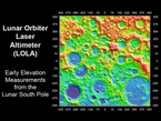
Data from LRO's Lunar Orbiter Laser Altimeter, or LOLA, however, indicates that exploring these areas will be challenging because the terrain is very rough. The roughness is probably a result of the lack of atmosphere and absence of erosion from wind or water, according to David Smith, LOLA principal investigator at Goddard.

LRO's other instruments also are providing data to help map the moon's terrain and resources. According to the first measurements from the Diviner instrument, large areas in the permanently shadowed craters are about minus 400 degrees Fahrenheit (33 Kelvin), more than cold enough to store water ice or hydrogen for billions of years.

The Lunar Reconnaissance Orbiter Camera is providing high-resolution images of permanently shadowed regions while lighting conditions change as the moon's south pole enters lunar summer.

LRO's Lyman Alpha Mapping Project, or LAMP, also is preparing to search for surface ice and frost in the polar regions. The instrument provides images of permanently shadowed regions illuminated only by starlight and the glow of interplanetary hydrogen emission. LAMP has provided information to confirm the instrument is working well on both the lunar night and day sides.

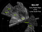
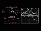
The Mini RF Technology Demonstration on LRO has confirmed communications capability and produced detailed radar images of potential targets for LRO's companion mission, the Lunar Crater Observation and Sensing Satellite, which will impact the moon's south pole on Oct. 9.

Meanwhile, LRO's Cosmic Ray Telescope for the Effects of Radiation instrument is exploring the lunar radiation environment and its potential effects on humans during record high, "worst-case" cosmic ray intensities accompanying the extreme solar minimum conditions of this solar cycle.

The scientists hope to gain many new insights by the overlay of the data gathered by all the different instruments. Tons of new images and results will come out of this survey and we all can be excited about this phase of the exploration of our closest neighbor.

NASA
Pictures of the article
Detailed Mapping of Moon's South Pole - Let the Moon Surveys Begin | Redshift live

Detailed Mapping of Moon's South Pole

Let the Moon Surveys Begin

The Lunar Reconnaissance Orbiter, or LRO, has successfully completed its testing and calibration phase and entered its mapping orbit of the moon. The spacecraft already has made significant progress toward creating the most detailed atlas of the moon's south pole to date.

Please update you current Adobe Flashplayer Version

The website of the Adobe Flashplayer:
http://www.adobe.com/de/products/flashplayer/

Scientists released preliminary images and data from LRO's seven instruments. "The LRO mission already has begun to give us new data that will lead to a vastly improved atlas of the lunar south pole and advance our capability for human exploration and scientific benefit," said Richard Vondrak, LRO project scientist.

LRO is scheduled for a one-year exploration mission in a polar orbit of about 31 miles above the lunar surface, the closest any spacecraft has orbited the moon. During the next year, LRO will produce a complete map of the lunar surface in unprecedented detail, search for resources and safe landing sites for human explorers, and measure lunar temperatures and radiation levels.

The south pole of the moon is of great interest to explorers because potential resources such as water ice or hydrogen may exist there. Permanently shadowed polar craters that are bitterly cold at their bottoms may hold deposits of water ice or hydrogen from comet impacts or the solar wind. The deposits may have accumulated in these "cold-trap" regions over billions of years. If enough of these resources exist to make mining practical, future long-term human missions to the moon potentially could save the considerable expense of hauling water from Earth.

First results from LRO's Lunar Exploration Neutron Detector, or LEND, indicate that permanently shadowed and nearby regions may harbor water and hydrogen. Additional observations will be needed to confirm this. LEND relies on a decrease in neutron radiation from the lunar surface to indicate the presence of water or hydrogen.

"If these deposits are present, an analysis of them will help us understand the interaction of the moon with the rest of the solar system," Vondrak said.

Data from LRO's Lunar Orbiter Laser Altimeter, or LOLA, however, indicates that exploring these areas will be challenging because the terrain is very rough. The roughness is probably a result of the lack of atmosphere and absence of erosion from wind or water, according to David Smith, LOLA principal investigator at Goddard.

LRO's other instruments also are providing data to help map the moon's terrain and resources. According to the first measurements from the Diviner instrument, large areas in the permanently shadowed craters are about minus 400 degrees Fahrenheit (33 Kelvin), more than cold enough to store water ice or hydrogen for billions of years.

The Lunar Reconnaissance Orbiter Camera is providing high-resolution images of permanently shadowed regions while lighting conditions change as the moon's south pole enters lunar summer.

LRO's Lyman Alpha Mapping Project, or LAMP, also is preparing to search for surface ice and frost in the polar regions. The instrument provides images of permanently shadowed regions illuminated only by starlight and the glow of interplanetary hydrogen emission. LAMP has provided information to confirm the instrument is working well on both the lunar night and day sides.

The Mini RF Technology Demonstration on LRO has confirmed communications capability and produced detailed radar images of potential targets for LRO's companion mission, the Lunar Crater Observation and Sensing Satellite, which will impact the moon's south pole on Oct. 9.

Meanwhile, LRO's Cosmic Ray Telescope for the Effects of Radiation instrument is exploring the lunar radiation environment and its potential effects on humans during record high, "worst-case" cosmic ray intensities accompanying the extreme solar minimum conditions of this solar cycle.

The scientists hope to gain many new insights by the overlay of the data gathered by all the different instruments. Tons of new images and results will come out of this survey and we all can be excited about this phase of the exploration of our closest neighbor.

NASA
Pictures of the article
» print article
Search
Astronomy Software

Solar Eclipse by Redshift

Solar Eclipse by Redshift for iOS

Observe, understand, and marvel at the solar eclipse on August 21, 2017! » more

Solar Eclipse by Redshift

Solar Eclipse by Redshift for Android

Observe, understand, and marvel at the solar eclipse on August 21, 2017! » more

Detailed Mapping of Moon's South Pole

Let the Moon Surveys Begin

The Lunar Reconnaissance Orbiter, or LRO, has successfully completed its testing and calibration phase and entered its mapping orbit of the moon. The spacecraft already has made significant progress toward creating the most detailed atlas of the moon's south pole to date.

Please update you current Adobe Flashplayer Version

The website of the Adobe Flashplayer:
http://www.adobe.com/de/products/flashplayer/

Scientists released preliminary images and data from LRO's seven instruments. "The LRO mission already has begun to give us new data that will lead to a vastly improved atlas of the lunar south pole and advance our capability for human exploration and scientific benefit," said Richard Vondrak, LRO project scientist.

LRO is scheduled for a one-year exploration mission in a polar orbit of about 31 miles above the lunar surface, the closest any spacecraft has orbited the moon. During the next year, LRO will produce a complete map of the lunar surface in unprecedented detail, search for resources and safe landing sites for human explorers, and measure lunar temperatures and radiation levels.

The south pole of the moon is of great interest to explorers because potential resources such as water ice or hydrogen may exist there. Permanently shadowed polar craters that are bitterly cold at their bottoms may hold deposits of water ice or hydrogen from comet impacts or the solar wind. The deposits may have accumulated in these "cold-trap" regions over billions of years. If enough of these resources exist to make mining practical, future long-term human missions to the moon potentially could save the considerable expense of hauling water from Earth.

First results from LRO's Lunar Exploration Neutron Detector, or LEND, indicate that permanently shadowed and nearby regions may harbor water and hydrogen. Additional observations will be needed to confirm this. LEND relies on a decrease in neutron radiation from the lunar surface to indicate the presence of water or hydrogen.

"If these deposits are present, an analysis of them will help us understand the interaction of the moon with the rest of the solar system," Vondrak said.

Data from LRO's Lunar Orbiter Laser Altimeter, or LOLA, however, indicates that exploring these areas will be challenging because the terrain is very rough. The roughness is probably a result of the lack of atmosphere and absence of erosion from wind or water, according to David Smith, LOLA principal investigator at Goddard.

LRO's other instruments also are providing data to help map the moon's terrain and resources. According to the first measurements from the Diviner instrument, large areas in the permanently shadowed craters are about minus 400 degrees Fahrenheit (33 Kelvin), more than cold enough to store water ice or hydrogen for billions of years.

The Lunar Reconnaissance Orbiter Camera is providing high-resolution images of permanently shadowed regions while lighting conditions change as the moon's south pole enters lunar summer.

LRO's Lyman Alpha Mapping Project, or LAMP, also is preparing to search for surface ice and frost in the polar regions. The instrument provides images of permanently shadowed regions illuminated only by starlight and the glow of interplanetary hydrogen emission. LAMP has provided information to confirm the instrument is working well on both the lunar night and day sides.

The Mini RF Technology Demonstration on LRO has confirmed communications capability and produced detailed radar images of potential targets for LRO's companion mission, the Lunar Crater Observation and Sensing Satellite, which will impact the moon's south pole on Oct. 9.

Meanwhile, LRO's Cosmic Ray Telescope for the Effects of Radiation instrument is exploring the lunar radiation environment and its potential effects on humans during record high, "worst-case" cosmic ray intensities accompanying the extreme solar minimum conditions of this solar cycle.

The scientists hope to gain many new insights by the overlay of the data gathered by all the different instruments. Tons of new images and results will come out of this survey and we all can be excited about this phase of the exploration of our closest neighbor.

NASA
Pictures of the article
» print article

Search
Astronomy Software

Solar Eclipse by Redshift

Solar Eclipse by Redshift for iOS

Observe, understand, and marvel at the solar eclipse on August 21, 2017! » more

Solar Eclipse by Redshift

Solar Eclipse by Redshift for Android

Observe, understand, and marvel at the solar eclipse on August 21, 2017! » more