Arabia Terra on Mars

Mars Express puts craters on a pedestal
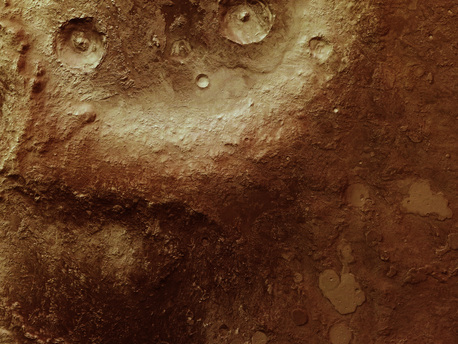
ESA’s Mars Express has returned new views of pedestal craters in the Red Planet’s eastern Arabia Terra.
Extending 159 km by 87 km, this image shows a region with an area of about 13865 sq km, a third of the size of Denmark. Named after a feature on Giovanni Schiaparelli’s 19th-century Mars map, Arabia Terra is part of the highlands of Mars, stretching east to west across 4500 km. With a ground resolution of about 18 m per pixel, the data were acquired near 27°N/56°E during orbit 7457 of Mars Express on 26 October 2009.

Extending 159 km by 87 km, this image shows a region with an area of about 13865 sq km, a third of the size of Denmark. Named after a feature on Giovanni Schiaparelli’s 19th-century Mars map, Arabia Terra is part of the highlands of Mars, stretching east to west across 4500 km. With a ground resolution of about 18 m per pixel, the data were acquired near 27°N/56°E during orbit 7457 of Mars Express on 26 October 2009.

Craters are perhaps the quintessential planetary geological feature. So much so that early planetary geologists expended a lot of effort to understand them. You could say they put craters on a pedestal. This latest image of Mars shows how the Red Planet does it in reality.

Craters are the result of impacts by asteroids, comets and meteorites. In a pedestal crater, the surrounding terrain is covered by pulverised rock thrown out of the crater. This material creates a platform or pedestal around the crater often with steep cliffs, and is usually rich in volatile materials such as water and ice.

Arabia Terra is part of the highlands of Mars, stretching east to west across 4500 km in the northern hemisphere, and named for a feature drawn on Giovanni Schiaparelli’s 19th-century map of Mars.

The whole area is characterised by steep-sided hills, valleys and ancient impact craters that have been extensively resurfaced by old lava flows and modified by profound erosion over millions of years. The eastern areas rise up to 4 km above the low-lying north-western parts. To the north, Arabia Terra drops and blends into the northern lowlands.

Pedestal craters are visible in this new view of a 159 km by 87 km region of eastern Arabia Terra, taken by the High Resolution Stereo Camera on ESA’s Mars Express orbiter.

The large crater to the top centre has a pedestal that looks like a skirt, rising almost up to the crater rim. Mounds and table mountains on the floors of the larger craters show layered deposits that could be the result of volcanic processes, or that may have been deposited by wind or water.

In the north (right), layered deposits appear as smooth plains covering the highlands. These were thought to have formed during the Late Noachian and Early Hesperian eras, about 4 billion years ago.

Later, the deposits experienced heavy erosion by wind and partially by water, leading to the variety of landscapes seen in this region today.

Source: ESA
Arabia Terra on Mars - Mars Express puts craters on a pedestal | Redshift live

Arabia Terra on Mars

Mars Express puts craters on a pedestal

ESA’s Mars Express has returned new views of pedestal craters in the Red Planet’s eastern Arabia Terra.
Extending 159 km by 87 km, this image shows a region with an area of about 13865 sq km, a third of the size of Denmark. Named after a feature on Giovanni Schiaparelli’s 19th-century Mars map, Arabia Terra is part of the highlands of Mars, stretching east to west across 4500 km. With a ground resolution of about 18 m per pixel, the data were acquired near 27°N/56°E during orbit 7457 of Mars Express on 26 October 2009.

Extending 159 km by 87 km, this image shows a region with an area of about 13865 sq km, a third of the size of Denmark. Named after a feature on Giovanni Schiaparelli’s 19th-century Mars map, Arabia Terra is part of the highlands of Mars, stretching east to west across 4500 km. With a ground resolution of about 18 m per pixel, the data were acquired near 27°N/56°E during orbit 7457 of Mars Express on 26 October 2009.

Craters are perhaps the quintessential planetary geological feature. So much so that early planetary geologists expended a lot of effort to understand them. You could say they put craters on a pedestal. This latest image of Mars shows how the Red Planet does it in reality.

Craters are the result of impacts by asteroids, comets and meteorites. In a pedestal crater, the surrounding terrain is covered by pulverised rock thrown out of the crater. This material creates a platform or pedestal around the crater often with steep cliffs, and is usually rich in volatile materials such as water and ice.

Arabia Terra is part of the highlands of Mars, stretching east to west across 4500 km in the northern hemisphere, and named for a feature drawn on Giovanni Schiaparelli’s 19th-century map of Mars.

The whole area is characterised by steep-sided hills, valleys and ancient impact craters that have been extensively resurfaced by old lava flows and modified by profound erosion over millions of years. The eastern areas rise up to 4 km above the low-lying north-western parts. To the north, Arabia Terra drops and blends into the northern lowlands.

Pedestal craters are visible in this new view of a 159 km by 87 km region of eastern Arabia Terra, taken by the High Resolution Stereo Camera on ESA’s Mars Express orbiter.

The large crater to the top centre has a pedestal that looks like a skirt, rising almost up to the crater rim. Mounds and table mountains on the floors of the larger craters show layered deposits that could be the result of volcanic processes, or that may have been deposited by wind or water.

In the north (right), layered deposits appear as smooth plains covering the highlands. These were thought to have formed during the Late Noachian and Early Hesperian eras, about 4 billion years ago.

Later, the deposits experienced heavy erosion by wind and partially by water, leading to the variety of landscapes seen in this region today.

Source: ESA
» print article
Related articles:
This map shows the Aram Chaos region of Mars - a crater 170 miles in diameter lying almost directly on the martian equator. In this region Mars Express found mineralogical evidence for large-scale deposits of ferric oxides helping to understand the climatic changes on Mars.
Mars Express

Mars Express zeros in on erosion features

» go to article
Lyot Crater, pictured here, is one of at least nine craters in the northern lowlands of Mars with exposures of hydrated minerals detected from orbit, according to a June 25, 2010, report.

These minerals, including phyllosilicates, have previously been found in thousands of small outcrops in the southern highlands of Mars, but had not previously been identified in the northern lowlands, which cover nearly half of the planet. The plentiful outcrops in the south have been interpreted as evidence that early Mars -- about 4 billion years ago -- had wet conditions necessary for producing phyllosilicates and possibly conducive to life.
PASADENA, Calif.

New Clues Suggest Wet Era on Early Mars Was Global

» go to article
Search
Astronomy Software

Solar Eclipse by Redshift

Solar Eclipse by Redshift for iOS

Observe, understand, and marvel at the solar eclipse on August 21, 2017! » more

Solar Eclipse by Redshift

Solar Eclipse by Redshift for Android

Observe, understand, and marvel at the solar eclipse on August 21, 2017! » more

Redshift 8 Premium

Redshift 8 Premium - Download Edition (Multilingua Edition)

Explore the universe from your PC with the award-winning and professional planetarium software - Languages: German, English, French
 » more

Redshift 8 Premium DL deutsch/engl 2

Redshift 8 Premium - Update from older versions

Update from Redshift 7 or older to the current version of the professional planetarium software - Languages: German, English, French
 » more

Redshift 8 Compact

Redshift 8 Compact - Download Edition

The professional planetarium software for beginners » more

Arabia Terra on Mars

Mars Express puts craters on a pedestal

ESA’s Mars Express has returned new views of pedestal craters in the Red Planet’s eastern Arabia Terra.
Extending 159 km by 87 km, this image shows a region with an area of about 13865 sq km, a third of the size of Denmark. Named after a feature on Giovanni Schiaparelli’s 19th-century Mars map, Arabia Terra is part of the highlands of Mars, stretching east to west across 4500 km. With a ground resolution of about 18 m per pixel, the data were acquired near 27°N/56°E during orbit 7457 of Mars Express on 26 October 2009.

Extending 159 km by 87 km, this image shows a region with an area of about 13865 sq km, a third of the size of Denmark. Named after a feature on Giovanni Schiaparelli’s 19th-century Mars map, Arabia Terra is part of the highlands of Mars, stretching east to west across 4500 km. With a ground resolution of about 18 m per pixel, the data were acquired near 27°N/56°E during orbit 7457 of Mars Express on 26 October 2009.

Craters are perhaps the quintessential planetary geological feature. So much so that early planetary geologists expended a lot of effort to understand them. You could say they put craters on a pedestal. This latest image of Mars shows how the Red Planet does it in reality.

Craters are the result of impacts by asteroids, comets and meteorites. In a pedestal crater, the surrounding terrain is covered by pulverised rock thrown out of the crater. This material creates a platform or pedestal around the crater often with steep cliffs, and is usually rich in volatile materials such as water and ice.

Arabia Terra is part of the highlands of Mars, stretching east to west across 4500 km in the northern hemisphere, and named for a feature drawn on Giovanni Schiaparelli’s 19th-century map of Mars.

The whole area is characterised by steep-sided hills, valleys and ancient impact craters that have been extensively resurfaced by old lava flows and modified by profound erosion over millions of years. The eastern areas rise up to 4 km above the low-lying north-western parts. To the north, Arabia Terra drops and blends into the northern lowlands.

Pedestal craters are visible in this new view of a 159 km by 87 km region of eastern Arabia Terra, taken by the High Resolution Stereo Camera on ESA’s Mars Express orbiter.

The large crater to the top centre has a pedestal that looks like a skirt, rising almost up to the crater rim. Mounds and table mountains on the floors of the larger craters show layered deposits that could be the result of volcanic processes, or that may have been deposited by wind or water.

In the north (right), layered deposits appear as smooth plains covering the highlands. These were thought to have formed during the Late Noachian and Early Hesperian eras, about 4 billion years ago.

Later, the deposits experienced heavy erosion by wind and partially by water, leading to the variety of landscapes seen in this region today.

Source: ESA
» print article

Search
Astronomy Software

Solar Eclipse by Redshift

Solar Eclipse by Redshift for iOS

Observe, understand, and marvel at the solar eclipse on August 21, 2017! » more

Solar Eclipse by Redshift

Solar Eclipse by Redshift for Android

Observe, understand, and marvel at the solar eclipse on August 21, 2017! » more